
Today was better than expected. Although it started near the motorway, this was much quieter being early Sunday morning, less traffic and I could hear the birds. There was scenery to one side, and the surface was less rough, although my fresher leg muscles might have helped.
Then the route suddenly branched off onto a peaceful country lane. All at once I was back in paradise, the birdsong was louder, there were lush green fields and animals. Even the surface was smooth, maybe it doesn’t need to be so rough, as the cars don’t go so fast.
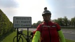
This seemed to go on for ever and as it was slightly downhill, my average speed was higher. All at once I was in Gretna. Of course I took a detour to Gretna Green ad allowed myself a break to take photos, there and again at the border.
After a very short stretch on a busy main road, the route took me back onto quiet country lanes.
Of course every day has ist challenge; today’s was Carlisle. It would have been so easy but I must have missed the sign for N7 and the communication beteeen Teasi (that is REALLY the so appropriate name of my bike-computer and sat-nav.) and me didn’t seem to be working again. The traffic was extreme and I had to get over a busy roundabout. No way was I doing it on the road.
After asking someone I found myself following the N7 & N10 along a tarred path by the river. Teasi didn’t want me to go that way, but I knew I would go via Dalston, where I could rejoin „my“ route (*)
I knew I had about 200 metres to climb, not my favourite for this to be at the end of the day, but it was drawn out over several kilometres. This proved to be as exciting as a day at the fun-fair. There were many steep dips and if I let myself go full speed down I got most of, sometimes all the way up the other side. Fortunately the road surface was good, so after the first couple I really let go, leaming forward and keeping low, giving me one adrenalin rush after another, especially on one occasion when the were hens at the side of the road. I just prayed they wouldn’t run across in front of me. Then there was one fairly steep ascent before last gradual downhill part.
(*) You may wonder how I planned the route. I read a book called „The Safer Way“ by Royston Wood. He did the trip several times in reverse and had previously had bad experiences with traffic. He had planned this route with help of Google Maps. The cycling routes were then only in the beta stage, and he adapted them. The routes to download are included with the book, along with all sorts of useful information like accommodation tips. He also explains how to adapt the routes and in my case reverse them.
That brings me to why I’m doing it „in reverse“. I knew I would have to dispose of the box after travelling one way. As my husband and I will be coming to Cornwall with a group of golfers in May, I can leave my bike there and we can take it home in the trailer a couple of weeks later. I had wondered why most end-to-enders seem to go from Land’s End to John o’Groats. As I told people about the strong head-winds in Scotland, 3 people told me independently that I was doing it „the wrong way round“!
Tourstats for the day:
89,8 km. 637 m. elevation, 6:43 bike-time, 8:14 total
-

- wp 20170409 11 11 55 rich
-

- wp 20170409 10 46 45 rich
-
- wp 20170409 11 24 28 pro

