…and day 4 just Mougás
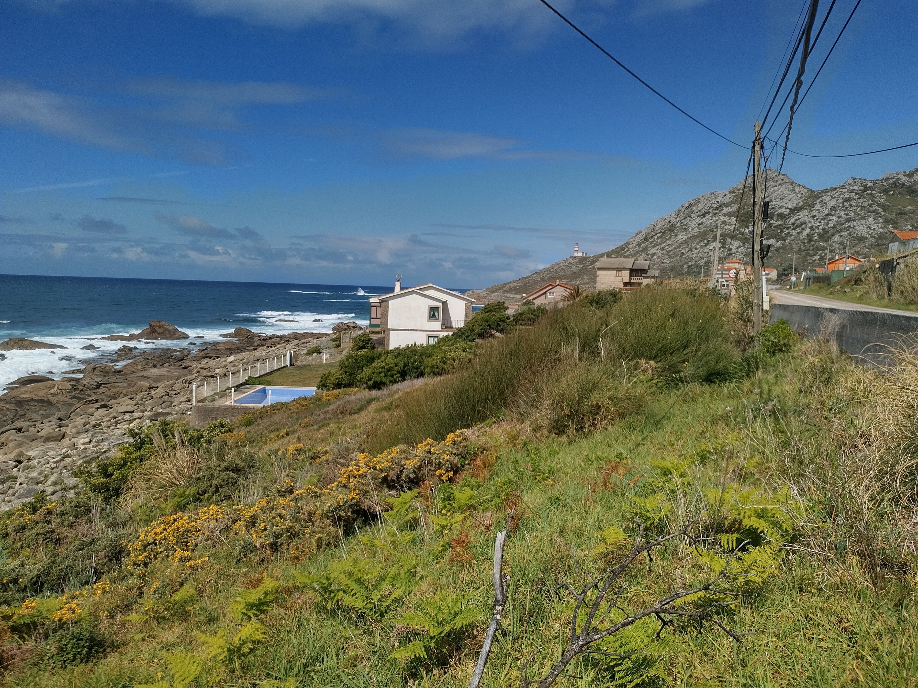
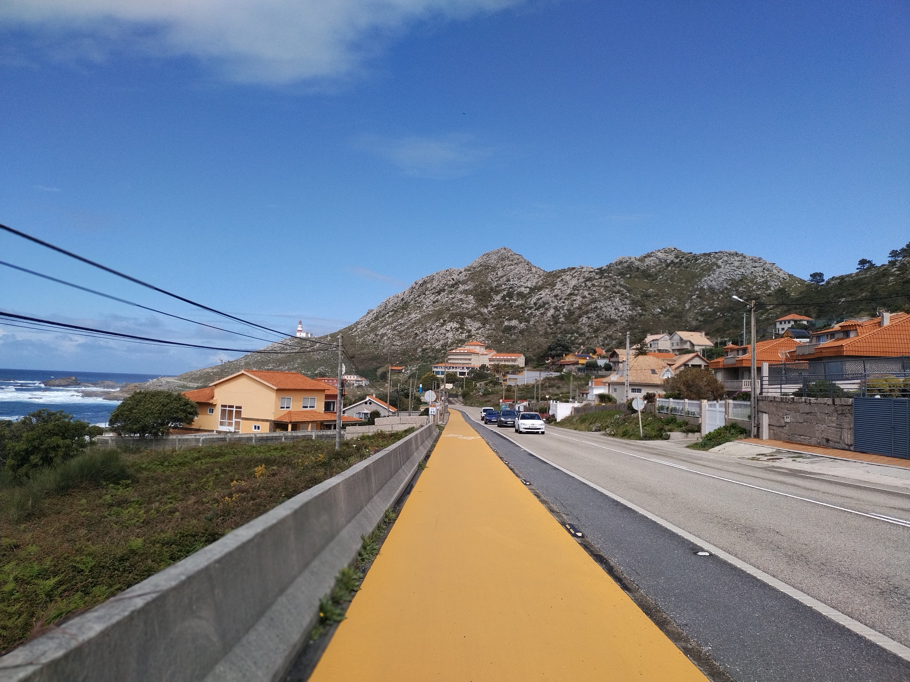
This day started with a long ride along the river in Portugal and back along the other side in Spain. This seemed to be the only way. I didn’t see any other bridge or ferry. The Portuguese side was very pleasant, mostly park-like on reddish brown tarmacked cycle paths. I was in for a shock when I arrived in Spain and my Garmin sent me on a difficult hiking (i e. pushing) path. Fortunately this soon turned into a “road”, partially tarmacked, partially unpaved. It is ran through the forest before coming into a village. After that it was all through the narrow streets of quaint little villages, thank goodness not cobblestoned, but windy with lots of ups and downs. I got a shock on coming out of La Guarda. I went towards the beach, expecting cycle paths at sea level similar to those in Portugal. Them my Garmin protested and at the same time a man pointed up the hill. It was so such a steep climb up that I had to push. The bright yellow cycle track was next to the main road on the clifftop! It stayed with the road for a while then went down sometimes almost to sea-level and always back up again! I was counting the miles again by the time I got to this lovely hotel!
I wasn’t too disappointed that it rained this morning, which gave me an excuse for a day off. What better place to stay
Dieser Tag begann mit einer langen Fahrt entlang des Flusses in Portugal und zurück auf der anderen Seite in Spanien. Dies schien der einzige Weg zu sein. Ich habe keine andere Brücke oder Fähre gesehen. Die portugiesische Seite war sehr angenehm, meist Park-ähnlich auf rotbraun geteerten Radwegen. Als ich in Spanien ankam, stand ich vor einem Schock als mein Garmin mich auf einen schwierigen Wander- (dh Schiebe-) Pfad dchicktrhhds Glücklicherweise wurde diese bald zu einer “Straße”, teils asphaltiert, teils unbefestigt. Es lief durch einen Wald, bevor es in ein Dorf kam. Danach ging es durch die engen Gassen uriger kleiner Dörfer, Gott sei Dank kein Kopfsteinpflaster, aber hin und her mit vielen Höhen und Tiefen. Als ich aus La Guarda herauskam, bekam ich einen Schock. Ich fuhr in Richtung Strand und erwartete Radwege auf Meereshöhe, ähnlich denen in Portugal. Da protestierte mein Garmin und gleichzeitig deutete ein Mann den Hügel hinauf. Es war so ein steiler Aufstieg, dass ich schieben musste. Der grellgelbe Radweg war neben der Hauptstraße auf den Klippen! Er blieb eine Weile auf der Straße, dann ging es manchmal fast bis auf Meereshöhe hinunter und immer wieder zurück hinauf! Ich habe die Kilometer wieder gezählt, bis ich in diesem schönen Hotel ankam!
Ich war nicht allzu enttäuscht, dass es heute Morgen geregnet hat, was mir eine Entschuldigung für einen freien Tag gab, Gibt es einen besseren Ort zum pausieren?
Mougàs.
This day started with a long ride along the river in Portugal and back along the other side in Spain. This seemed to be the only way. I didn’t see any other bridge or ferry. The Portuguese side was very pleasant, mostly park-like on reddish brown tarmacked cycle paths. I was in for a shock when I arrived in Spain and my Garmin sent me on a difficult hiking (i e. pushing) path. Fortunately this soon turned into a “road”, partially tarmacked, partially unpaved. It is ran through the forest before coming into a village. After that it was all through the narrow streets of quaint little villages, thank goodness not cobblestoned, but windy with lots of ups and downs. I got a shock on coming out of La Guarda. I went towards the beach, expecting cycle paths at sea level similar to those in Portugal. Them my Garmin protested and at the same time a man pointed up the hill. It was so such a steep climb up that I had to push. The bright yellow cycle track was next to the main road on the clifftop! It stayed with the road for a while then went down sometimes almost to sea-level and always back up again! I was counting the miles again by the time I got to this lovely hotel!
I wasn’t too disappointed that it rained this morning, which gave me an excuse for a day off. What better place to stay
Dieser Tag begann mit einer langen Fahrt entlang des Flusses in Portugal und zurück auf der anderen Seite in Spanien. Dies schien der einzige Weg zu sein. Ich habe keine andere Brücke oder Fähre gesehen. Die portugiesische Seite war sehr angenehm, meist Park-ähnlich auf rotbraun geteerten Radwegen. Als ich in Spanien ankam, stand ich vor einem Schock als mein Garmin mich auf einen schwierigen Wander- (dh Schiebe-) Pfad dchicktrhhds Glücklicherweise wurde diese bald zu einer “Straße”, teils asphaltiert, teils unbefestigt. Es lief durch einen Wald, bevor es in ein Dorf kam. Danach ging es durch die engen Gassen uriger kleiner Dörfer, Gott sei Dank kein Kopfsteinpflaster, aber hin und her mit vielen Höhen und Tiefen. Als ich aus La Guarda herauskam, bekam ich einen Schock. Ich fuhr in Richtung Strand und erwartete Radwege auf Meereshöhe, ähnlich denen in Portugal. Da protestierte mein Garmin und gleichzeitig deutete ein Mann den Hügel hinauf. Es war so ein steiler Aufstieg, dass ich schieben musste. Der grellgelbe Radweg war neben der Hauptstraße auf den Klippen! Er blieb eine Weile auf der Straße, dann ging es manchmal fast bis auf Meereshöhe hinunter und immer wieder zurück hinauf! Ich habe die Kilometer wieder gezählt, bis ich in diesem schönen Hotel ankam!
Ich war nicht allzu enttäuscht, dass es heute Morgen geregnet hat, was mir eine Entschuldigung für einen freien Tag gab, Gibt es einen besseren Ort zum pausieren?